Reading Environments
tl;dr
You already know spaces shape people. A casino changes a neighborhood. A library can make you feel safe before anyone speaks to you. A building can make you feel watched before anyone looks at you.
The harder question is how to study that influence without turning it into either vibes or blunt metrics.
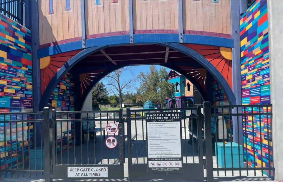
Here are just some of the Magical Bridge Playground Rules:
Keep the gate closed at all times.
Please enjoy food and drinks outside of the Playground.
Wear appropriate footwear at all times. Bare feet, flip flops, and high heels are not permitted.
Cursing, yelling, and hitting are not permitted.
Use park at your own risk.
We hope you have most magical time here, and that you will visit often.
Let’s analyze. This case study combines observation, interviews, spatial analysis, and close reading of everyday artifacts.
You can already read the room
We intuit that environments act on us: that a park does something different than a parking lot, that a welcoming building feels different from a hostile one, that a casino two blocks away changes what it means to grow up somewhere. People regularly talk about places as if they have personalities. A library is “welcoming.” The alley is “unsafe.” A building “feels hostile.” We say these things casually, without diagrams or footnotes, and everyone seems to understand what we mean.
Brutalism taught us that materials have honesty, that form carries meaning whether we name it or not. Jane Jacobs showed us that streets have eyes. We describe neighborhoods as safe or dangerous, as vibrant or dead, as if these were properties of the place itself and not just the people in it.
This intuition is correct. You can sense that the community center isn’t serving the community it was built for. You suspect the new development will change things in ways the impact assessment won’t capture. The space is already doing something long before the effects shows up in a spreadsheet.
So how do you investigate that?
Background to Foreground
Human-centered design interviews people. It watches them use things. It asks what they need. This works beautifully when the problem is a product, a service, an interface—something people can point to and describe.
Spaces are trickier. Someone avoids a building without knowing why. Someone drives thirty minutes to relax when a park exists nearby. Someone feels unwelcome in a place that was ostensibly designed for them. You hear where they go, not why they don’t go elsewhere.
Meanwhile, urban planning counts things. Traffic patterns, demographic shifts, square footage, walkability scores. These metrics describe a space but don’t capture what it does.
All in all, the space becomes a backdrop, not a subject of inquiry in its own right.
Our work treats environments as participants in research.
This means reading an environment the way an archaeologist reads artifacts—as encoding information that people can’t or won’t articulate.
A case in point
In North Fair Oaks, California, we were asked to help redesign a small community library.
The library was cramped. It had no bathroom. It shared a building with the Human Services Office. A mile and a half away sat a well-funded community center with playgrounds, meeting rooms, shade, and trees.
The community avoided the center. The tiny library was the real place to be. On paper, this made no sense.
So we started asking what the environment itself was doing.
Walk with me
First, we looked at the neighborhood from above, then walked its main routes, then paid attention to the smallest details people encounter when they arrive somewhere. Each step changed how the previous one made sense.
From the satellite view, North Fair Oaks doesn’t look neutral
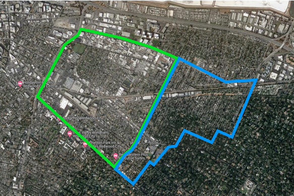
The western half, where the lower-income, predominantly Spanish-speaking community lives, is grey. The grey is because the place uses more concrete and fewer trees. There is dense housing, industrial lots, asphalt, and the entire thing is bisected by major roads and commuter rails. The eastern half is green: trees, spacing, shade.
From above, systemic neglect isn’t a feeling. It’s recorded as land use.
You can already see where comfort has been allowed to exist.
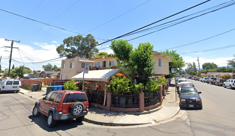
From the street view, those patterns of segregation turn into experience.
Walking down Middlefield Road, there’s a moment where the bike lane disappears. Traffic intensifies. Fences gain barbed wire. You try to go to a park by cutting through the parking lot to escape the heat. A solitary tree that is growing in another yard provides an overhanging branch which in turn produces a strip of shade and someone is already sleeping there.
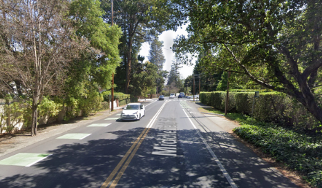
Then you pass a Pizza Hut.
Just after it, the bike lane reappears. Trees line the road. Houses gain gardens. The traffic lights turn into stop signs and roundabouts. The street seems to exhale. The Pizza Hut is not an official boundary but there may as well be a border patrol. It marks where the infrastructure completely changes. The picture below is the same street as above but if you go a few blocks East.
From the object view, you can see the elements that comprise the space, like atoms that bond together to create a unique whole with particular qualities.
At the Red Morton Community Center, the welcome sign announces how much it costs to enter (not a lot but it’s the thought that counts). Every entrance sign is in English. Spanish appears occasionally, smaller, as an afterthought. Rule plaques are posted everywhere: playgrounds, fields, entrances.
The space doesn’t say “welcome.” Its material culture says “prove you’re allowed.”
Even when the amenities are technically public, the accumulation of rules produces anxiety. Governance is made visible in the font choices and people worry they’ll do something wrong.
At the library things are different. First of all, they have ukuleles. There is no checkpoint and the most official looking thing is a circulation desk that sits in the back of the space. Spanish comes first in the bulletin board and English is right there next to it. The library used to have self-check out machines, but they never got used because people wanted to chat with the staff.
From the interviews, it is no wonder that one of the first things we heard about the library was:
“It’s a place that doesn’t make you feel like you’re on food stamps.”
That sentence is devastatingly precise. It tells you exactly what the other spaces are doing wrong.
The whole picture
The value of this study was not in any single dataset, but in how different kinds of evidence reinforced one another.
Satellite imagery highlighted structural segregation. Walking the streets revealed how that segregation was experienced physically. Close attention to objects such as signs and rules explained why certain spaces produced anxiety. Interviews confirmed how residents adapted to these conditions.
Across scales, the same patterns repeated. From land use and bike infrastructure to font size and sign placement, the environment consistently communicated that it was designed for some and not others.
Putting these altogether pointed to the fact that people living in the grey area of North Fair Oaks crowded to the library because that is where belonging was, but the library is too small for everyone. So instead, when given a chance, the residents go to other areas where the grass is truly greener. Since everyone disperses out for relaxation there are few opportunities for people to mix and form tighter communities.
For places that work on paper, but not in practice
This kind of study is most useful when a space technically works, but does not work well for the people it is meant to serve.
Interviews alone tend to reveal how people adapt. Metrics alone tend to show compliance with requirements. Neither captures how a place is actually experienced. Treating the environment itself as an active subject of inquiry makes those dynamics visible, and makes it possible to design spaces that people use because they want to—not because they are supposed to.
Sophisticated Research.
Nuanced results.
617-807-0047
yuri@yzdesignworks.com